As Howick and districts count down to the 175th anniversary next year, the Times continues its series by Alan La Roche giving readers a glimpse of life as it used to be. The countdown began at the 170th in 2017
- By Alan La Roche, Howick Historian, alanlaroche@xtra.co.nz
The Howick Borough Council was Howick’s local body from 1952 until 1989 during a period of increasing population, improved infrastructure, reserves and sports facilities.
In 1952, Howick had more than 2000 residents and, with the expanded boundaries to include Bradbury Road, Hutchinson Road and the southern side of Union Road all taken from Manukau County Council, there were increased responsibilities.
Manukau County Council had neglected these areas putting in 1.25 inch water pipes, instead of six inch pipes in Howick Borough. There were large, deep potholes in these roads. Howick had its own water supply from Pigeon Mountain and all houses had water meters, unlike other parts of Auckland.
Howick Borough Council with a mayor and councillors all living in the borough, had a very personal interest in spending rates wisely. Everyone seemed to know their councillor and mayor in a friendly community.
The mayor was expected to dress in red for playcentre Christmas parties. Traffic lights were considered by the Borough Council to be erected outside the Howick Post Office in 1953 but traffic volumes “were not adequate for traffic lights”.
Stockade Hill Reserve was planted with thousands of daffodils by the Howick Horticultural Society volunteers which were magnificent for several years. Howick had overflowing septic tanks leaking sewage into streams. Auckland sewage was released from Orakei Wharf outflow on outgoing tides that blew back onto Howick beaches creating several metres of detritus to get to cleaner water for swimming.
A reticulated sewage system to Mangere forced a 30 per cent rate rise without objections from Howick residents. Howick had advanced flood protection, a volunteer fire brigade and a sea rescue organisation by 1958.
After World War II, Auckland needed an international airport. After considering several alternatives, it would be either Pakuranga or Mangere. Mangere had fewer fogs in winter, so Mangere was chosen. All Auckland region local bodies were asked to contribute for the cost in October 1962.
Howick Borough Council gave $8000 and said the greatest cost should be the responsibility of Auckland City, not the outer suburbs.
Manukau City Council wanted amalgamation with Howick Borough, but Howick fought for their independence. Manukau wanted the more highly valued suburbs to extract more rates. Howick considered joining with Otara, but Otara councillors thought Manukau City would give a better deal.
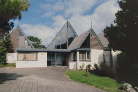
The Howick Town Hall and council offices had been demolished and the site sold for a supermarket. Howick Borough Council bought the Windross home in Cook Street which became their offices until the Howick Borough Council offices were built in Moore Street and officially opened by Governor-General Sir Keith Holyoake in June 1979.
This solid, well-designed borough headquarters still standing on the corner of Fencible Drive and Moore Street, gave a sense of permanence and real stability to Howick. But certain politicians claimed “big is better” and “it will give reduced rate demands”.
Some in Howick claimed amalgamation “destroys the heart of the community”. Even Council-controlled organisations such as Watercare, Ports of Auckland and the Airport might be taxed giving more to central Government with the possibility of paid directors and a profit motive with shareholding investors.
Howick Borough amalgamated with Manukau City in 1989. Howick then became a Ward in Manukau City with its own Community Board which continues today as the Howick Local Board.
There were seven wards in Manukau City with councillor participation. Then in 2010 Manukau City amalgamated with other cities from Franklin to Rodney to become the new Auckland (Super) City.


