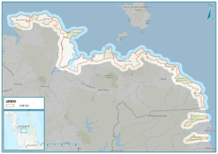
Auckland Council’s second Shoreline Adaptation Plan (SAP) pilot – which targets Beachlands and the eastern coast – has been launched with a focus on Auckland’s south-eastern coastline.
Previously known as Coastal Management Plans, SAPs explore how Auckland Council-owned coastal land and assets can be adapted to manage the impacts of natural hazards, including erosion, coastal inundation, flooding, and climate change, while considering the needs and values of mana whenua and the local community.
Recognising the environmental and landscape value of the shoreline, SAPs also work to promote the preservation and restoration of the coastal environment for future generations.
Once completed, SAPs will provide site-specific adaptation strategies that will outline the preferred management response for each coastal area over the next 100 years.
Together, all SAPs will help inform the sustainable management of council’s assets along the coast including the development of a regional prioritisation process for funding. This will ensure cost-effective management of new and existing structures and the development of a resilient future shoreline.
Auckland Council’s general manager resilient land and coasts, Paul Klinac, says Auckland has more than 3200km of diverse coastline that is much-loved by residents and visitors alike.
“But the coast also presents a range of issues and hazards that we need to better understand and plan for. Issues like complex coastal processes and the impacts of coastal hazards, climate change, and the need to adapt are just some of the challenges we want to discuss further with mana whenua and our coastal communities,” says Klinac.
The “Beachlands and East” SAP will cover the shoreline area between Pine Harbour Marina and the Auckland Council boundary just south of Matingarahi near Orere Point.
The pilot will run from late-October to mid-February 2022 and public engagement will take place both online and (alert level permitting) in person.
In addition to the South-East pilot, the council has commenced the Te Waimanawa (Little Shoal Bay just over the Auckland Harbour Bridge) Shoreline Adaptation ‘Concept’ Plan. The plan will follow the established Shoreline Adaptation Plan technical and community engagement framework but will take high level adaptation strategies down to detailed options for implementation.
As a concept plan, results will be focused on the discrete area of Little Shoal Bay. However, to ensure a holistic approach, results will (at a later date) be aligned within the wider Kaipātiki Shoreline Adaptation Plan as an ‘area of interest’.
Chair of the Environment and Climate Change Committee, Councillor Richard Hills, says it’s fantastic to see this crucial work ramping up across Auckland.
“The two large pilot areas and one discrete concept plan will build a great foundation to build upon as we begin the complex yet important process of adapting our coast as we begin to see the impacts of climate change,”says Hills.
“This work will also support mana whenua and local residents to help shape the future, armed with accurate data, while protecting our environment and prevent us making kneejerk decisions that can lead to poor outcomes for our coastal environments and waterways
“This work will be funded regionally as part of the climate initiatives in our recently approved 10-year Budget.”


